
By Kyle Starkes, Solutions Engineer for Nearmap
In response to electricity price hikes, renewable energy is set to have its biggest year ever as global capacity sources are expected to jump by 107 gigawatts. This increase alone totals more than the installed capacity of entire countries. Solar, both large utility scale and small distributed systems, is the big winner of this rise in renewable energy capacity — accounting for two-thirds of the year’s projected increase.
Greater governmental policy support and reduced operating costs has made solar more widely available and affordable. Because of this, solar providers have the potential to service more customers than ever before. However, the influx of prospects brings with it the challenge of scaling operations.
To capitalize on the solar trend, providers are turning to technology to streamline their processes and maximize efficiency. This is where aerial imagery for solar comes into play. By leveraging cutting-edge mapping technologies, businesses can gain current and contextual insights that enable data-driven decisions for the property of interest — all without leaving the office.
Using aerial imagery allows solar providers to scale their business by cutting the time and cost of going onsite as they can view what they need to bid, win, and manage their projects from any connected device.

Upgrading tradition with technology
Traditionally, site assessment relied on manual surveys and ground-based measurements. This is time-consuming, costly, and prone to human error. Using accurate aerial imagery, solar providers can forgo tradition and speed up processes with the efficiency and precision of technology.
Moreover, traditional methods may not provide real-time or up-to-date information, as site conditions change over time. This lack of accurate and timely data can lead to suboptimal project planning, delays, and increased costs.
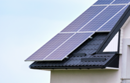
Accuracy is the foundation of aerial imagery’s efficacy for solar projects. This requires capturing and publishing detailed information about a property’s topography, shading, orientation, and more. But not all providers are created equal. While some think surveys every few years is sufficient, the gap in captures creates inaccuracies that could lead to avoidable mistakes.
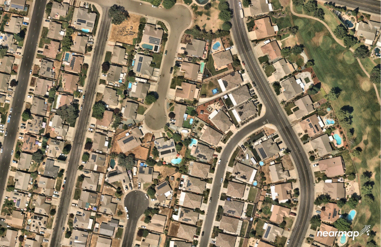
The best aerial imagery providers routinely conduct flyovers and upload fresh content so that solar businesses are making decisions with relevant location data. At Nearmap, we capture more than 80% of the population, up to three times per year in high-resolution.
Aerial imagery for solar 101
Capturing and publishing aerial imagery for solar providers requires advanced technologies and equipment. That’s because resolution is everything and not every camera is up to the task. At Nearmap, our industry leading 5.6 – 7.5cm resolution allows solar providers to inspect even the most granular details.
But what you see is just the beginning when using Nearmap. Within every capture are hundreds of insights that most aerial imagery providers fail to surface. With consistent true orthographic imagery, digital surface models (DSM), and artificial intelligence (AI) data layers, Nearmap makes it easy to understand and leverage property data.
True ortho imagery and DSM
Aerial imagery delivers more than a top-down view of the world. True ortho aerial imagery and DSM can provide greater solar data. This enables providers to conduct a virtual shade analysis, design a system that will perform optimally, and create custom proposals at scale.

Solar and AI
Artificial intelligence can be used to automate solar workflows — from prospecting to designing to managing. With over 50 AI data layers, Nearmap AI automatically identifies key features that solar providers look for, including properties with and without solar panels. This instant feature extraction supercharges cost and time savings with minimal manual effort.
Nearmap integrations are release-ready, allowing solar providers to maintain a seamless workflow alongside software updates. Fresh surveys are published automatically to ensure that professionals are using the latest content. Nearmap offers integrations into a wide-range of applications, including GIS, CAD, 3D visualization, and asset management platforms.
By combining aerial intelligence technologies, solar providers can obtain a comprehensive understanding of a property’s conditions and make data-driven decisions throughout the project lifecycle.

Use case: Aerialytic
Aerialytic, a North American based solar technology company, is pioneering AI-driven solar design automation. Their software helps solar providers scale their business by allowing them to create instant designs using artificial intelligence and effectively provide accurate installation quotes to customers.
- “If I wanted to do a single design for every home in the United States, it would take me over 2,200 years. With Nearmap data and coverage, coupled with our technology, we empower solar professionals to accelerate adoption and growth.” Bardia Andalib, CEO and Co-Founder of Aerialytic

Aerialytic uses advanced aerial imagery models to streamline high-resolution renderings for their solar design projects. Details matter in quoting, and aerial imagery empowers Aerialytic’s quotes to be as accurate as possible.
Aerialytic not only creates solutions for today. The company is continuously evolving for the needs of tomorrow. They utilize regularly updated aerial imagery and data, making certain that their solar estimation productions are always current, optimized, and ready to meet the dynamic needs of the solar industry.
As sustainable energy becomes more accessible, it will grow in demand. Because of this, solar companies need to be able to prospect and service customers at scale. This can’t be done with traditional onsite assessments. The right aerial imagery provider will enable solar professionals to instantly view, inspect, and quote projects using current and contextual property data.
Explore how Nearmap is powering solar businessesSponsored Content by Nearmap


Tell Us What You Think!