

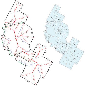
Pictured is Pictometry high-resolution aerial imagery of a neighborhood in Las Vegas, which EagleView Technologies would use to provide solar contractors with a detailed review of roof measurements. Pictometry oblique imagery is captured at a 45° angle on all four sides of a structure to provide a 360° view.
Google Maps was a pioneering technology for remote solar prospecting. Installers could scroll across neighborhoods, picking the best south-facing roofs with the fewest apparent shading issues. They could make rough measurements, estimating roof tilt, and build a sales proposal. They could drive up to a house—one with a sunny property, or so it seemed according to Google Maps—with an array layout and cost in mind, only to find a colossal oak tree casting its shadow on most of the roof.
While satellite imagery continues to get clearer, it fails in a number of ways that are important to a solar contractor. Specifically, it lacks specificity.
More important for the industry than a potential hide-and-seek oak tree is the lack of precise measurement and a sales proposal based on too many assumptions. Pictometry software and imagery combined with technology from EagleView is eliminating the need to assume, offering detailed measurements of roofs.
Accurate forecasting of energy production is critical to ensuring that a solar system meets expectations and the cost of an installation is justified. The only way to accurately forecast is to know the precise measurements of a roof and exactly how shading could impede energy production. Under-performing systems are, for any installer, an albatross.
“You want to deliver precise values to a potential customer, not a rough interpretation,” said Chris Giannoumis, an engineer at Standard Energy Solutions, the residential arm of Standard Solar, who is NABCEP-certified in PV installation and technical sales. He goes a step further: “We want our systems to overproduce, by just a little bit, so we look great.”
Giannoumis can provide production certainty with assistance from Pictometry, an EagleView company, which offers web-based access to new and historical images of specific properties. Using the PictometryOnline (POL) platform, solar contractors can access high-resolution aerial imagery of properties—top-down and north, south, east and west views—and use analytical tools to perform basic measurements—such as roof surface area, heights of trees, distances—to determine a property’s suitability for a PV system.
After the sale closes, contractors can order the EagleView Solar Roof Report. The report includes precise measurements of the roof along with a .dxf file that can be imported to a CAD system for the design of the array and development of the plan set, which saves time.
After the installation, the report can be presented to the home or property owner as part of the warranty packet. It includes five aerial views of the property and detailed measurements of the roof. Sometimes customers will show the report to neighbors or friends, which turns it into a referral tool.
Giannoumis is the only residential solar engineer at Standard Energy Solutions. Work ebbs and flows, and instead of hiring an additional engineer to deal with busy times, the company searched for ways to increase one person’s productivity. Standard Energy Solutions found EagleView Technologies and decided to try it on a few houses. They used caution: Giannoumis sent crews to measure the houses and also received measurements from EagleView.
“The report would get a measurement of 26.05 ft, and the guys got a measurement of 26 because they rounded,” he said. “We decided what EagleView is doing is good, and it’s going to work for us.”
Standard Energy Solutions has used Pictometry software and EagleView solar reports on more than 20 houses and not once has an installer or subcontractor said a measurement provided by EagleView was incorrect, Giannoumis said.
The accuracy comes from Pictometry’s 16-megapixel Pentaview imaging system that carries the United States Geological Survey (USGS) camera certification and comprises five custom-designed cameras and an acquisition computer with sensor control hardware and software. When the images are taken, every square foot of an area is captured in high-resolution detail, from both orthogonal and oblique angles, giving Pictometry imagery something traditional aerial images or even satellite and GPS mapping can’t provide: a detailed oblique view of any feature.
EagleView can provide contractors with detailed roof measurements.
The only limitation for EagleView Technologies, according to Giannoumis, is that small obstructions can be unaccounted. But he says having a crew measure a single exhaust pipe for size, location and shading is a reasonable expense paired with the capabilities of Pictometry.
To learn more about EagleView Technologies and PictometryOnline and how it can help solar businesses, visit pictometry.com/solar.
Backstory: EagleView Technologies
Brothers-in-law Dave Carlson, a roofing contractor, and Chris Pershing, a software engineer, each have a passion for solving problems, and they’re always asking, “Is there a better way?” The question arose again when they discussed the challenge of accurately measuring roofs.
They searched for a simple, accurate technology to determine roof measurements, but the software did not exist. They collaborated on ways to create new technology to produce a remote roof measurement using available photography.
Chris started by using his wife’s ornamental birdhouses as models to prototype software that would create a 3D model of roofs using photographs. It was a collaborative process with Chris refining the prototypes using feedback from Dave’s field experience and measurements taken on actual roofs.
After many months of collaboration, the brothers-in-law had created accurate software and quickly filed a software patent. EagleView was launched in February 2008 as the first remote aerial roof measurement service.


Tell Us What You Think!