
By Johan Jaques, Senior Meteorologist, KISTERS group
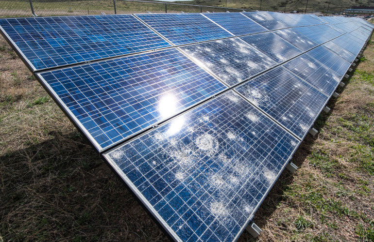
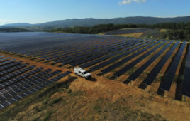
Photo by Dennis Schroeder / NREL
According to the U.S. Energy Information Administration, in 2020 solar power was good for 3% of total energy production in the United States, with prediction of a 5% contribution in 2022. Meanwhile, its share may well rise to 14% of the U.S. total in 2035 and 20% in 2050.
With this current and anticipated increasing importance of solar power in a globally warming world, where precipitation events are likely to become more extreme following Assessment Report 6 (AR6) from the IPCC, it becomes increasingly important to protect solar panels against hazardous weather like wildfires, extreme winds, and large-hail events.
Occurrence of damaging hail
Hail, especially large hail, can damage solar panels both externally and internally (microcracks), leading to sub-optimal performance of the power output efficiency. On the long run, the functionality of the panels may further deteriorate as dust or water penetrates these cracks; even worse, malfunctioning solar panels might cause fires.
Large hail events remain rare. The period of occurrence is mainly limited to summer (April to September) and some areas are more prone to their occurrence than others. However, many areas in the Untied States, which are bound to be the largest producers of solar energy, are equally the areas most at risk.
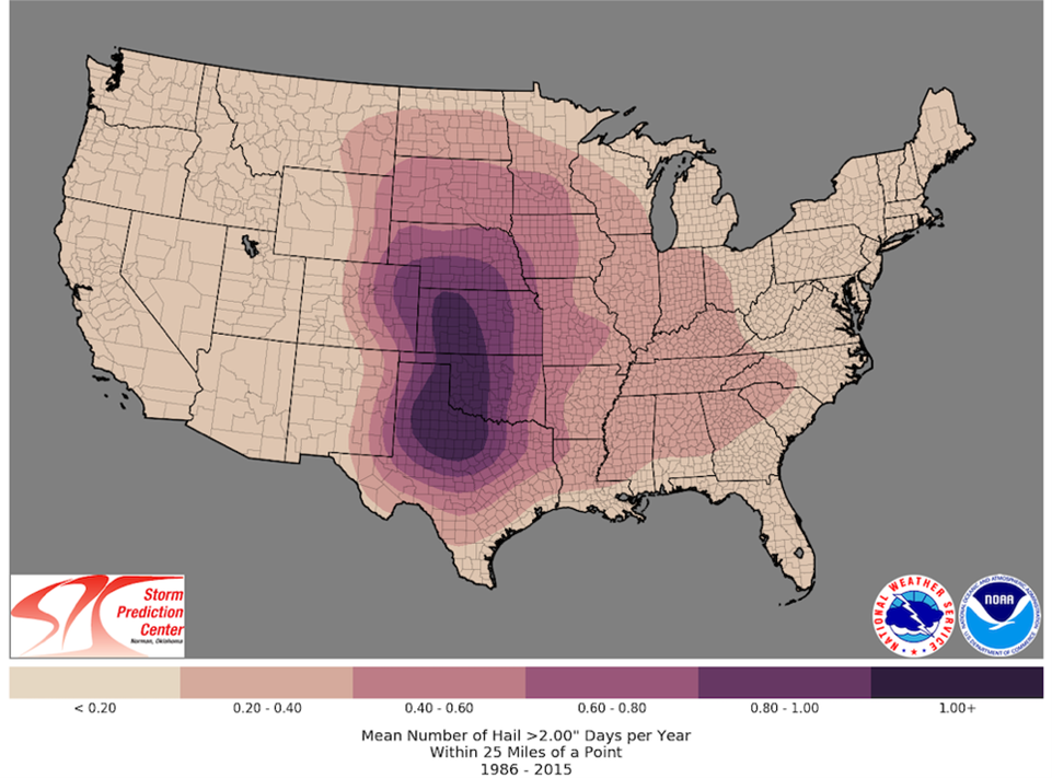
From the above map, Texas, Oklahoma, Kansas, and Nebraska seem to be most at risk, with some parts facing more than once a year hail events with hailstone sizes > 2 inches.
Soaring insurance costs
Whilst these large hail events remain rare, the damage caused by them can be very significant. Due to a combination of a historical correction and some recent cases in Texas, insurance prices are soaring (rising as much as 400% over the last few years). Whereas in the recent past, one would have seen insurance polices with a minimum $100,000 deductible, or 5% of the physical damage limit, that has grown over the last few years to $250,000 and 5%, and there have been cases reported of $1,000,000 and 15% in Texas. Very often, maximum physical damage limits are defined in recent polices, instead of full physical damage coverage.
Utility owners are therefore increasingly looking at preventing costs and using weather data to protect their assets. There are different timescales over which awareness about the potential hail damage danger or actionable information can be generated from these data.
Protective measures: Forecast range timescale – up to 3 days ahead
In this timeframe, utility operators are seeking to raise their staff awareness of a potentially hail generating situation, where we typically would refer to the use of numerical weather prediction (NWP) models or statistical models. Though larger scale NWP models typically do not forecast the occurrence of hail directly, several model parameters, instability indices and simulated radar reflectivity can give indirect hints. There are several good models available, some in the public domain and some commercially. Some suggestions of freely available models follow (non-exhaustive):
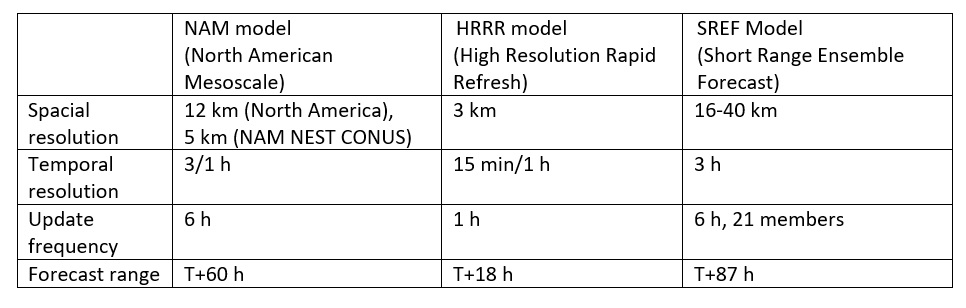
Besides the classical model parameters, the HRRR model also produces an interesting parameter called GRMAX01, which provides one-hour forecasts of maximum last hour hail/graupel diameter at the surface.
The above proposed models NAM and HRRR are deterministic, while SREF provides ensemble data that can be used to derive the probability of severe weather events. Some parameters like instability/hail (especially for HRRR outputs) are considered experimental.
Protective Measures: Near Real Time – 0-2 hours ahead
In this time range, utility operators are looking to operate a decision support system, aiming at moving the solar panels to a safe position to lower the risk of large hail breaking up the panels. Besides the above-mentioned NWPs, a solution can be offered by using so-called nowcasts (short range forecasts using observed radar and advanced extrapolation algorithms) based on polarimetric X-band type radar installations.
X-band radars typically have a useable radius of 30-60 km. Beside the classical parameters like reflectivity and precipitation intensity, they also provide reliable information about the precipitation type that is reaching the surface, including summer hail. X-band radars also have the advantage of high resolution and high update frequency.
By combining the precipitation type with nowcasting techniques, and applying thresholds to these data, an early warning system for risk of hail with sufficient reaction time can be put in place.
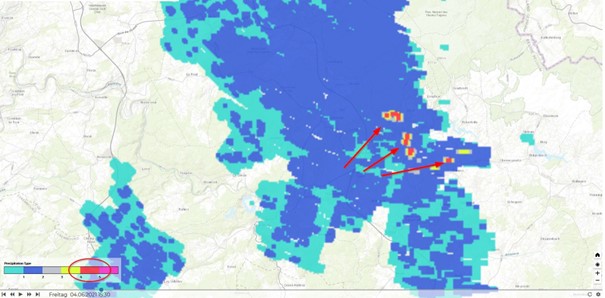
Example of precipitation type from X-band radar, set at a 125-m resolution. Red areas are areas with observed large hail.
Post event analysis
Once a hailstorm damage event has occurred, it is crucial to be able to prove that large hail occurred at the utility site, especially as some parametric insurances based on agreed thresholds (e.g., the occurrence of hail stones greater than 2 in.) are emerging.
Besides evidence delivered by X-band radars, onsite hail sensors are essential. The minimum they should provide is good statistics about distribution of sizing of hailstone in time, and number of impacts per hail size class per event.

Distribution of hail diameter over time during a hail event
Platform
In setting up protective measures against large hail events, utilities are facing quite different data types issued from different forecasting centers, X-band radar providers, own sensor data, all for which reliable archiving and alarming functionality is required. Thus, utility operators might be looking to providers offering end-to-end solutions that can be assembled on a single platform or solution.
A number of candidates present itself, but certainly datasphere looks like a very promising solution. Datasphere integrates sensor data as well as forecast and nowcast data from any source. Furthermore, KISTERS North America also offers its own hail sensors and nowcast technology.
Johan Jaques(°1965) has a master degree in physical geography/meteorology from the KU Leuven (Belgium). After working for 8 years as operational meteorologist and later additionally as instructor advanced meteorology and lead forecaster for the Belgian Airforce Nat Met. Centre, he worked for more than 20 year for a private weather company MeteoGroup (nowadays part of DTN). Since 2019, he is working as Solution Owner for a number of weather related cloud solutions at and as meteorological adviser of KISTERS.
Tell Us What You Think!